-
×
 1 × $39.45
 -
×
 ASO 35% 350,000ppm ACTIVATED STABILIZED LIQUID OXYGEN 2 OZ Bio-Available Oxygen-Enhanced Formula
1 × $31.95
ASO 35% 350,000ppm ACTIVATED STABILIZED LIQUID OXYGEN 2 OZ Bio-Available Oxygen-Enhanced Formula
1 × $31.95 -
×
SZCO Supplies Viking Sword
1 × $48.95
-
×
Snap-N-Go EX Universal Infant Car Seat Carrier
1 × $62.95
-
×
Medicine Cards: The Discovery of Power Through the Ways of Animals
1 × $21.95
-
×
D&D Spellbook Cards Deck (Martial Powers and Races)
1 × $20.95
-
×
Last Samurai Japanese Sword Katana Honor w/Free Stand (Original Version) Original Version
1 × $43.95
-
×
DC Collectibles Batman Arkham Knight: Nightwing Action Figure
1 × $30.95
-
×
New Style RTIC 20 Oz Stainless Steel Tumbler 20oz
1 × $29.95
-
×
Lint Remover,Clothes Shaver - Extra Long 68" Electric Cord Operated Fabric Shaver- Fuzz & Fluff Remover - Suitable to Use on Pilling Surfaces,Such As Sweater,Coat,Carpet,Glove and More
1 × $25.95
-
×
Windi The Gaspasser by Fridababy The All-Natural Solution for Baby Colic and Gas Relief 1 pack
1 × $21.95
-
×
31" Gladius Roman Sword Gladiator Julius Caesar
1 × $48.95
-
×
Simply Genius (Single Roll) Patterned Duct Tape Roll Craft Supplies for Kids Adults Colored Duct Tape Colors, Panda Party
1 × $16.95
-
×
Bayer Advantage II Topical Flea Treatment for Small Dogs, 3-10 lbs 6 doses 3-10 lb
1 × $66.95
-
×
OWI-536 All Terrain 3-in-1 RC Robot Kit - ATR 1
1 × $49.95
-
×
Solo: A Star Wars Story Soundtrack Solo: A Star Wars Story (Original Motion Picture Soundtrack)
1 × $8.95
-
×
Bayes Mineral Oil Wood Bamboo Protectant 8oz 1 8 oz
1 × $11.95
-
×
MyGift Tilting Whiskey Scotch Clear Glass, Highball Tumbler Party Glasses (10oz), Set of 4 in Gift Box Titled Design
1 × $35.95
-
×
How to Create Stunning Digital Photography
1 × $24.95
-
×
WATER SOURCE TC13NL 13x1-1/4BRS Tank Tee
1 × $41.95
-
×
TILLYOU Lilac Pleated Crib Skirt, 100% Natural Cotton, Nursery Crib Bedding Skirt for Baby Boys and Girls, 14'? Drop Lilac
1 × $18.95
-
×
Game of Thrones: Season 1 (BD) [Blu-ray] Blu-ray
April 19, 2016
1 × $23.95

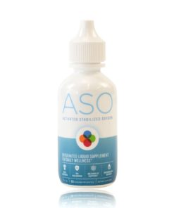 ASO 35% 350,000ppm ACTIVATED STABILIZED LIQUID OXYGEN 2 OZ Bio-Available Oxygen-Enhanced Formula
 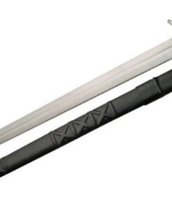 SZCO Supplies Viking Sword
  Snap-N-Go EX Universal Infant Car Seat Carrier
 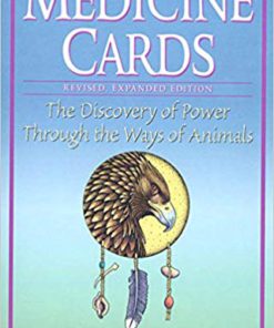 Medicine Cards: The Discovery of Power Through the Ways of Animals
 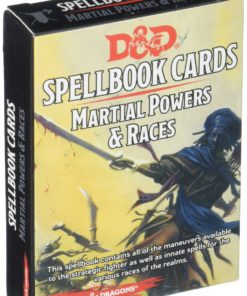 D&D Spellbook Cards Deck (Martial Powers and Races)
  Last Samurai Japanese Sword Katana Honor w/Free Stand (Original Version) Original Version
 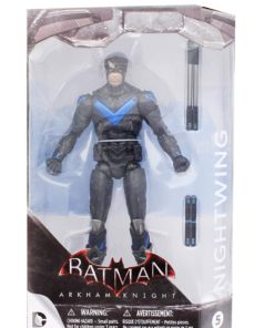 DC Collectibles Batman Arkham Knight: Nightwing Action Figure
 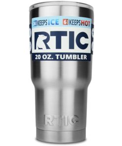 New Style RTIC 20 Oz Stainless Steel Tumbler 20oz
  Lint Remover,Clothes Shaver - Extra Long 68" Electric Cord Operated Fabric Shaver- Fuzz & Fluff Remover - Suitable to Use on Pilling Surfaces,Such As Sweater,Coat,Carpet,Glove and More
 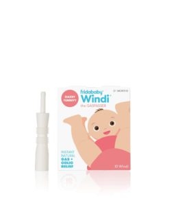 Windi The Gaspasser by Fridababy The All-Natural Solution for Baby Colic and Gas Relief 1 pack
  31" Gladius Roman Sword Gladiator Julius Caesar
  Simply Genius (Single Roll) Patterned Duct Tape Roll Craft Supplies for Kids Adults Colored Duct Tape Colors, Panda Party
 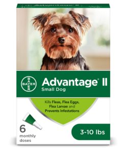 Bayer Advantage II Topical Flea Treatment for Small Dogs, 3-10 lbs 6 doses 3-10 lb
  OWI-536 All Terrain 3-in-1 RC Robot Kit - ATR 1
  Solo: A Star Wars Story Soundtrack Solo: A Star Wars Story (Original Motion Picture Soundtrack)
  Bayes Mineral Oil Wood Bamboo Protectant 8oz 1 8 oz
  MyGift Tilting Whiskey Scotch Clear Glass, Highball Tumbler Party Glasses (10oz), Set of 4 in Gift Box Titled Design
  How to Create Stunning Digital Photography
  WATER SOURCE TC13NL 13x1-1/4BRS Tank Tee
  TILLYOU Lilac Pleated Crib Skirt, 100% Natural Cotton, Nursery Crib Bedding Skirt for Baby Boys and Girls, 14'? Drop Lilac
 ![Game of Thrones: Season 1 (BD) [Blu-ray] Blu-ray
April 19, 2016](https://swiftsly.com/wp-content/uploads/2023/11/81nPad8gCL-247x296.jpg) Game of Thrones: Season 1 (BD) [Blu-ray] Blu-ray
April 19, 2016
Game of Thrones: Season 1 (BD) [Blu-ray] Blu-ray
April 19, 2016 
![Appalachian Trail: Pleasant Pond to Katahdin Map [Maine] (National Geographic Topographic Map Guide, 1513)](https://swiftsly.com/wp-content/uploads/2024/01/91m7JKM5M6L.jpg "Appalachian Trail: Pleasant Pond to Katahdin Map [Maine] (National Geographic Topographic Map Guide, 1513) 1")
![Appalachian Trail: Pleasant Pond to Katahdin Map [Maine] (National Geographic Topographic Map Guide, 1513) - Image 2](https://swiftsly.com/wp-content/uploads/2024/01/91csl3qrsUL.jpg "Appalachian Trail: Pleasant Pond to Katahdin Map [Maine] (National Geographic Topographic Map Guide, 1513) 2")
![Appalachian Trail: Pleasant Pond to Katahdin Map [Maine] (National Geographic Topographic Map Guide, 1513) - Image 3](https://swiftsly.com/wp-content/uploads/2024/01/A194jz6yzL.jpg "Appalachian Trail: Pleasant Pond to Katahdin Map [Maine] (National Geographic Topographic Map Guide, 1513) 3")
![Appalachian Trail: Pleasant Pond to Katahdin Map [Maine] (National Geographic Topographic Map Guide, 1513) - Image 4](https://swiftsly.com/wp-content/uploads/2024/01/61JPmiy7xaL.jpg "Appalachian Trail: Pleasant Pond to Katahdin Map [Maine] (National Geographic Topographic Map Guide, 1513) 4")
![Appalachian Trail: Pleasant Pond to Katahdin Map [Maine] (National Geographic Topographic Map Guide, 1513) - Image 5](https://swiftsly.com/wp-content/uploads/2024/01/712vpqqWciL-1.jpg "Appalachian Trail: Pleasant Pond to Katahdin Map [Maine] (National Geographic Topographic Map Guide, 1513) 5")

 6")
 7")
 8")
 9")


Appalachian Trail: Pleasant Pond to Katahdin Map [Maine] (National Geographic Topographic Map Guide, 1513)
Description
Features:
Product Details:
- Publisher : National Geographic Maps; 2022nd edition (January 1, 2022)
- Language : English
- Map : 40 pages
- ISBN-10 : 1597756504
- ISBN-13 : 01
- Item Weight : 2.68 ounces
- Dimensions : 4.1 x 0.3 x 9.3 inches
- Best Sellers Rank: #219,139 in Books (See Top 100 in Books) #221 in United States Atlases & Maps (Books) #271 in Maps (Books) #490 in Hiking & Camping Excursion Guides (Books)
- #221 in United States Atlases & Maps (Books)
- #271 in Maps (Books)
| Dimensions | 9.4 × 4.3 × 0.2 in |
|---|---|
| Ean | 9781597756501 |
| Mpn | TI00001513 |
| Upc | 749717915138 |
| GTIN | 09781597756501 |
| Isbn | 1597756504 |
| ISBN10 | 1597756504 |
| ISBN13 | 9781597756501 |
| Brand | National Geographic Maps |
PAYMENT POLICY
SHIPPING POLICY
Most items are shipped within one business day via UPS within the Continental United States.
- Canada shipment can take up to 10 days
- Alaska, Hawaii, and Puerto Rico shipment can take up to 10 days, and some items may not be permitted to ship to these locations.
- If any shipment is not permitted to your area, full refund will be issued within two business days.
RETURNS POLICY
All returns accepted within 30 days after receiving the item.
- Refund given as money back (no exchanges)
- Return Shipping to be paid by buyer, unless item defective or damaged.
- 15% Restocking fee applies unless return due to defective or damaged product.
- Perishable or Hazardous Goods are not returnable. Returns may require compliance with Manufacturer policies.
FEEDBACK
We take our reputation seriously. We buy and sell online, so we understand the value of trust. If you are unsatisfied with your order for any reason, please Contact Us and we will work with you to resolve it to your satisfaction.
Related products
-35%
-27%

Original price was: $29.90.$21.95Current price is: $21.95.
-16%
Original price was: $63.90.$53.95Current price is: $53.95.
-38%
Original price was: $20.90.$12.95Current price is: $12.95.
-20%
Original price was: $43.90.$34.95Current price is: $34.95.
-16%

-12%
Original price was: $93.90.$82.95Current price is: $82.95.
-33%

![Appalachian Trail: Pleasant Pond to Katahdin Map [Maine] (National Geographic Topographic Map Guide, 1513)](https://swiftsly.com/wp-content/uploads/2024/01/91m7JKM5M6L-100x100.jpg)