-
×
 1 × $18.95
 -
×
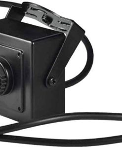
 Panlong 8-Way AV Switch RCA Switcher 8 in 1 Out Composite Video L/R Audio Selector Box for DVD STB Game Consoles
1 × $26.95
Panlong 8-Way AV Switch RCA Switcher 8 in 1 Out Composite Video L/R Audio Selector Box for DVD STB Game Consoles
1 × $26.95 -
×
Bergen Marzipan 54 Piece Assorted Fruit Box Tray
1 × $26.50
-
×
Absolute Eyewear Solutions 5996 Laptop Sleeve Real Tree Pink Camo, 15.6 in.
1 × $12.95
-
×
WEICHUAN New Sell Vintage Steampunk Goggles Glasses Cosplay Punk Gothic 1 Antique Silver
1 × $15.95
-
×
Bayer K9 Advantix II Flea, Tick and Mosquito Prevention for Dogs, 6 Dose 6 doses Over 55 lb
1 × $75.95
-
×
Aquapod Bottle Launcher - Launch 2 Liter Bottles Up to 100 ft in the Air
1 × $46.95
-
×
Ama_Trulystep MSC03 Copper Alcohol Moonshine Ethanol Still Spirits Boiler Distiller, 20 Litres
3 × $164.95
-
×
K&H Pet Products K&H Manufacturing Snuggle Up Bird Warmer Small/Medium (3" x 5") Gray
1 × $41.95
-
×
Thermajohn Long Johns Thermal Underwear for Men Fleece Lined Base Layer Set for Cold Weather X-Large Black
1 × $33.95
-
×
Magnaturals 37101 Jungle Vine Bridge
1 × $41.95
-
×
Natural Balance Limited Ingredient Diets Dry Dog Food - Sweet Potato & Venison Formula 26 lb
1 × $76.95
-
×
22 Chicken Charm Poultry Leg Bands - Includes Americas Favorite Super Hero's
1 × $17.95
-
×
Lexar Professional 633x 64GB SDXC UHS-I Card
2 × $14.95
-
×
D&D Spellbook Cards Deck (Martial Powers and Races)
1 × $20.95
-
×
Arm & Hammer Multiple Cat Litter Deodorizer with Baking Soda 1 Pack
1 × $14.95
-
×
Shamanic Experience: A Practical Guide to Psychic Powers
1 × $21.95
-
×
UGREEN 3.5mm Audio Stereo Y Splitter Extension Cable 3.5mm Male to 2 Port 3.5mm Female for Earphone, Headset Splitter Adapter, Compatible for iPhone, Samsung, LG, Tablets, MP3 Players, Metal Black
2 × $11.95
-
×
58" Legend of Zelda Master Sword Leather Universal Belt Strap Holder Link Hyrule Frog Buckle
1 × $28.95
-
×
J-Tech Digital Scroll Endurance Wired Mouse Ergonomic Vertical USB Mouse with Adjustable Sensitivity (600/1000/1600 DPI), Removable Palm Rest & Thumb Buttons - Reduces Hand/Wrist Pain (Wired)
1 × $17.95
-
×
Vividsun Green Leaf Flower Crown Eucalyptus Crown Wedding Bridal Maternity Photo Props Headpiece A/Purple
1 × $22.95
-
×
50 Things To See With A Small Telescope
1 × $14.95
-
×
Out of the Abyss (Dungeons & Dragons)
2 × $35.95
-
×
Suncutters Rear Window Shade
1 × $13.95
-
×
DJI ND16 Filter for Phantom 3 Professional & Advanced Quadcopter
1 × $18.95
-
×
ICD-10-CM 2016: The Complete Official Draft Code Set (ICD-10-CM the Complete Official Codebook)
1 × $82.95
-
×
Mann-Filter C 25 114/1 Air Filter Pack of 1
1 × $15.95
-
×
The Rights of Man
1 × $15.95

 Panlong 8-Way AV Switch RCA Switcher 8 in 1 Out Composite Video L/R Audio Selector Box for DVD STB Game Consoles
  Bergen Marzipan 54 Piece Assorted Fruit Box Tray
  Absolute Eyewear Solutions 5996 Laptop Sleeve Real Tree Pink Camo, 15.6 in.
 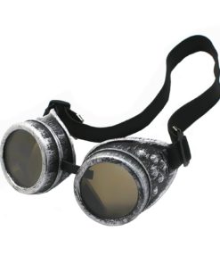 WEICHUAN New Sell Vintage Steampunk Goggles Glasses Cosplay Punk Gothic 1 Antique Silver
 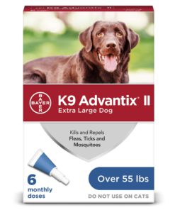 Bayer K9 Advantix II Flea, Tick and Mosquito Prevention for Dogs, 6 Dose 6 doses Over 55 lb
 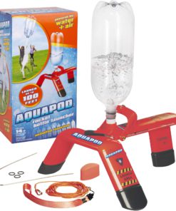 Aquapod Bottle Launcher - Launch 2 Liter Bottles Up to 100 ft in the Air
 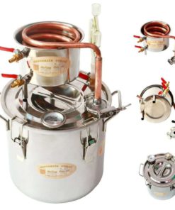 Ama_Trulystep MSC03 Copper Alcohol Moonshine Ethanol Still Spirits Boiler Distiller, 20 Litres
  K&H Pet Products K&H Manufacturing Snuggle Up Bird Warmer Small/Medium (3" x 5") Gray
  Thermajohn Long Johns Thermal Underwear for Men Fleece Lined Base Layer Set for Cold Weather X-Large Black
  Magnaturals 37101 Jungle Vine Bridge
  Natural Balance Limited Ingredient Diets Dry Dog Food - Sweet Potato & Venison Formula 26 lb
  22 Chicken Charm Poultry Leg Bands - Includes Americas Favorite Super Hero's
  Lexar Professional 633x 64GB SDXC UHS-I Card
  D&D Spellbook Cards Deck (Martial Powers and Races)
  Arm & Hammer Multiple Cat Litter Deodorizer with Baking Soda 1 Pack
  Shamanic Experience: A Practical Guide to Psychic Powers
  UGREEN 3.5mm Audio Stereo Y Splitter Extension Cable 3.5mm Male to 2 Port 3.5mm Female for Earphone, Headset Splitter Adapter, Compatible for iPhone, Samsung, LG, Tablets, MP3 Players, Metal Black
  58" Legend of Zelda Master Sword Leather Universal Belt Strap Holder Link Hyrule Frog Buckle
  J-Tech Digital Scroll Endurance Wired Mouse Ergonomic Vertical USB Mouse with Adjustable Sensitivity (600/1000/1600 DPI), Removable Palm Rest & Thumb Buttons - Reduces Hand/Wrist Pain (Wired)
  Vividsun Green Leaf Flower Crown Eucalyptus Crown Wedding Bridal Maternity Photo Props Headpiece A/Purple
  Suncutters Rear Window Shade
  DJI ND16 Filter for Phantom 3 Professional & Advanced Quadcopter
 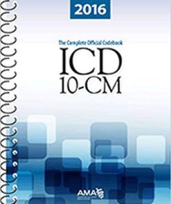 ICD-10-CM 2016: The Complete Official Draft Code Set (ICD-10-CM the Complete Official Codebook)
 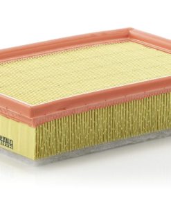 Mann-Filter C 25 114/1 Air Filter Pack of 1
  The Rights of Man
![Appalachian Trail, Swatara Gap to Delaware Water Gap [Pennsylvania] (National Geographic Topographic Map Guide) (National Geographic Topographic Map Guide, 1507)](https://swiftsly.com/wp-content/uploads/2023/12/91gTRmP7mWL.jpg "Appalachian Trail, Swatara Gap to Delaware Water Gap [Pennsylvania] (National Geographic Topographic Map Guide) (National Geographic Topographic Map Guide, 1507) 1")
![Appalachian Trail, Swatara Gap to Delaware Water Gap [Pennsylvania] (National Geographic Topographic Map Guide) (National Geographic Topographic Map Guide, 1507) - Image 2](https://swiftsly.com/wp-content/uploads/2023/12/91LqdKQBXuL.jpg "Appalachian Trail, Swatara Gap to Delaware Water Gap [Pennsylvania] (National Geographic Topographic Map Guide) (National Geographic Topographic Map Guide, 1507) 2")
![Appalachian Trail, Swatara Gap to Delaware Water Gap [Pennsylvania] (National Geographic Topographic Map Guide) (National Geographic Topographic Map Guide, 1507) - Image 3](https://swiftsly.com/wp-content/uploads/2023/12/A1fkkjYz6L.jpg "Appalachian Trail, Swatara Gap to Delaware Water Gap [Pennsylvania] (National Geographic Topographic Map Guide) (National Geographic Topographic Map Guide, 1507) 3")
![Appalachian Trail, Swatara Gap to Delaware Water Gap [Pennsylvania] (National Geographic Topographic Map Guide) (National Geographic Topographic Map Guide, 1507) - Image 4](https://swiftsly.com/wp-content/uploads/2023/12/71eZrYDiYqL.jpg "Appalachian Trail, Swatara Gap to Delaware Water Gap [Pennsylvania] (National Geographic Topographic Map Guide) (National Geographic Topographic Map Guide, 1507) 4")
![Appalachian Trail, Swatara Gap to Delaware Water Gap [Pennsylvania] (National Geographic Topographic Map Guide) (National Geographic Topographic Map Guide, 1507) - Image 5](https://swiftsly.com/wp-content/uploads/2023/12/712vpqqWciL-2.jpg "Appalachian Trail, Swatara Gap to Delaware Water Gap [Pennsylvania] (National Geographic Topographic Map Guide) (National Geographic Topographic Map Guide, 1507) 5")

 (National Geographic Topographic Map Guide, 1507) 6")
 (National Geographic Topographic Map Guide, 1507) 7")
 (National Geographic Topographic Map Guide, 1507) 8")
 (National Geographic Topographic Map Guide, 1507) 9")
 10")

Appalachian Trail, Swatara Gap to Delaware Water Gap [Pennsylvania] (National Geographic Topographic Map Guide) (National Geographic Topographic Map Guide, 1507)
Description
• Waterproof • Tear-Resistant • Topographic MapThe Swatara Gap to Delaware
Water Gap Topographic Map Guide makes a perfect traveling companion when
traversing the northeastern Pennsylvania section of the Appalachian Trail
(A.T.). The trail in this section of Pennsylvania primarily travels across
flat, rocky ridges mixed with strenuous climbs in and out various gaps.
Between Swatara Gap and Wind Gap, the A.T. weaves in and out of Pennsylvania
State Game Lands as it follows the long ridge of Blue Mountain. From Wind Gap
north, the A.T. follows the ridge of Kittatinny Mountain on its way to the
Delaware Water Gap.Each A.T. Topographic Map Guide includes detailed
topographic maps at a detail of 1 inch = 1 mile. Each page is centered on the
A.T. and overlaps with the adjacent pages so there is little chance of getting
lost. Along the bottom of each page is a trail profile that shows the distance
between shelters, camping areas, and trail access points. The map and trail
profile provide a step by step visual guide to hiking the trail, mile by
rugged mile. The Topographic Map Guide is built for all levels of hiking
enthusiasts, from the day tripper to the multi month ‘thru-hiker’. The front
pages of the printed Topographic Map Guide include resupply information, town
inset maps, camping options, and much more.Every Topographic Map Guide is
printed on “Backcountry Tough” waterproof, tear-resistant paper. A full UTM
grid is printed on the map to aid with GPS navigation.Other features found on
this map include: 501 Shelter, Allentown Shelter, Bake Oven Knob Shelter,
Delaware Water Gap, Eagles Nest Shelter, Eckville Shelter, George W.
Outerbridge Shelter, Hamburg, Kirkridge Shelter, Lehigh River, Leroy A. Smith
Shelter, Palmerton, Port Clinton, Stroudsburg, Sunfish Pond, Swatara Gap,
Swatara State Park, The Pinnacle, William Penn Shelter, Wind Gap, Windsor
Furnace Shelter, Worthington State Forest.Map Scale = 1:63,360Folded Size =
4.25″ x 9.25″ Read more
Features:
Product Details:
- Publisher : Natl Geographic Society Maps; 2022nd edition (January 1, 2022)
- Language : English
- Map : 40 pages
- ISBN-10 : 159775644X
- ISBN-13 : 40
- Item Weight : 2.72 ounces
- Dimensions : 4.1 x 0.2 x 9.1 inches
- Best Sellers Rank: #811,509 in Books (See Top 100 in Books) #732 in United States Atlases & Maps (Books) #775 in Maps (Books) #2,333 in Hiking & Camping Excursion Guides (Books)
- #732 in United States Atlases & Maps (Books)
- #775 in Maps (Books)
| Dimensions | 9.33 × 4.21 × 0.24 in |
|---|---|
| Ean | 0749717915077 |
| Mpn | TI00001507 |
| Upc | 749717915077 |
| GTIN | 09781597756440 |
| Isbn | 159775644X |
| ISBN10 | 159775644X |
| ISBN13 | 9781597756440 |
| Brand | Natl Geographic Society Maps |
PAYMENT POLICY
SHIPPING POLICY
Most items are shipped within one business day via UPS within the Continental United States.
- Canada shipment can take up to 10 days
- Alaska, Hawaii, and Puerto Rico shipment can take up to 10 days, and some items may not be permitted to ship to these locations.
- If any shipment is not permitted to your area, full refund will be issued within two business days.
RETURNS POLICY
All returns accepted within 30 days after receiving the item.
- Refund given as money back (no exchanges)
- Return Shipping to be paid by buyer, unless item defective or damaged.
- 15% Restocking fee applies unless return due to defective or damaged product.
- Perishable or Hazardous Goods are not returnable. Returns may require compliance with Manufacturer policies.
FEEDBACK
We take our reputation seriously. We buy and sell online, so we understand the value of trust. If you are unsatisfied with your order for any reason, please Contact Us and we will work with you to resolve it to your satisfaction.
Related products
-20%

-35%
-27%

Original price was: $29.90.$21.95Current price is: $21.95.
-42%

Original price was: $18.90.$10.95Current price is: $10.95.
-31%

Original price was: $25.90.$17.95Current price is: $17.95.
-24%

Original price was: $32.90.$24.95Current price is: $24.95.
-38%

Original price was: $20.90.$12.95Current price is: $12.95.
-30%

Original price was: $26.90.$18.95Current price is: $18.95.
![Appalachian Trail, Swatara Gap to Delaware Water Gap [Pennsylvania] (National Geographic Topographic Map Guide) (National Geographic Topographic Map Guide, 1507)](https://swiftsly.com/wp-content/uploads/2023/12/91gTRmP7mWL-100x100.jpg)