-
×
 1 × $15.95
 -
×
 The Kids' Yoga Deck: 50 Poses and Games
1 × $20.95
The Kids' Yoga Deck: 50 Poses and Games
1 × $20.95 -
×
Swingline Stapler, Light Duty Desktop Stapler, 20 Sheet Capacity, Black (S7040501) Pack of 1
1 × $13.95
-
×
WLPackaging 3/16 700 ft x 12" Small Bubble Cushioning Wrap, Perforated Every 12"
1 × $34.95
-
×
Knights Templar Armor Shield.
1 × $53.95
-
×
Mammalian Anatomy: The Cat
1 × $55.95
-
×
Electrolysis Enhancer - 16 Fl. Oz. (6 Bottles/Pack),BOGO, Order Today to GET an Extra Bottle at NO Additional Cost!
1 × $37.95
-
×
50 Things To See With A Small Telescope
1 × $14.95
-
×
Gerber EAB Lite Pocket Knife [31-000345]
1 × $18.95
-
×
Moleskine Classic Notebook, Hard Cover, Large (5" x 8.25") Ruled/Lined, White
1 × $19.95
-
×
BLACK+DECKER AF-100-3ZP String Trimmer Replacement Spool with 30 Feet of .065-Inch Line
2 × $17.95
-
×
Black PU Leather Ergonomic High Back Executive Best Desk Task Office Chair
1 × $77.95
-
×
8 Tier Cascade Wedding Cake Stand (STYLE R800)
1 × $98.50
-
×
NADAMOO Wireless Barcode Scanner 328 Feet Transmission Distance USB Cordless 1D Laser Automatic Barcode Reader Handhold Bar Code Scanner with USB Receiver for Store, Supermarket, Warehouse
1 × $41.95
-
×
Mars Attacks! DVD
October 28, 2008
1 × $10.95
-
×
BLACK+DECKER AF-100 String Trimmer Replacement Spool with 30 Feet of .065-Inch Line 30-Feet, 0.065-Inch
1 × $12.95
-
×
 Stinger Total Detox w/ B2 and Creatine
1 × $19.95
Stinger Total Detox w/ B2 and Creatine
1 × $19.95 -
×
Bushcraft 101: A Field Guide to the Art of Wilderness Survival
1 × $18.95

 The Kids' Yoga Deck: 50 Poses and Games
  Swingline Stapler, Light Duty Desktop Stapler, 20 Sheet Capacity, Black (S7040501) Pack of 1
  WLPackaging 3/16 700 ft x 12" Small Bubble Cushioning Wrap, Perforated Every 12"
  Knights Templar Armor Shield.
  Mammalian Anatomy: The Cat
  Electrolysis Enhancer - 16 Fl. Oz. (6 Bottles/Pack),BOGO, Order Today to GET an Extra Bottle at NO Additional Cost!
 ![Gerber EAB Lite Pocket Knife [31-000345]](https://swiftsly.com/wp-content/uploads/2020/05/51ddQqp6E0L-247x296.jpg) Gerber EAB Lite Pocket Knife [31-000345]
Gerber EAB Lite Pocket Knife [31-000345]  Moleskine Classic Notebook, Hard Cover, Large (5" x 8.25") Ruled/Lined, White
  BLACK+DECKER AF-100-3ZP String Trimmer Replacement Spool with 30 Feet of .065-Inch Line
  Black PU Leather Ergonomic High Back Executive Best Desk Task Office Chair
  8 Tier Cascade Wedding Cake Stand (STYLE R800)
  NADAMOO Wireless Barcode Scanner 328 Feet Transmission Distance USB Cordless 1D Laser Automatic Barcode Reader Handhold Bar Code Scanner with USB Receiver for Store, Supermarket, Warehouse
  Mars Attacks! DVD
October 28, 2008
Mars Attacks! DVD
October 28, 2008  BLACK+DECKER AF-100 String Trimmer Replacement Spool with 30 Feet of .065-Inch Line 30-Feet, 0.065-Inch
  Stinger Total Detox w/ B2 and Creatine
  Bushcraft 101: A Field Guide to the Art of Wilderness Survival
![Appalachian Trail: Delaware Water Gap to Schaghticoke Mountain Map [New Jersey, New York] (National Geographic Topographic Map Guide, 1508)](https://swiftsly.com/wp-content/uploads/2023/12/91R8bYJItpL.jpg "Appalachian Trail: Delaware Water Gap to Schaghticoke Mountain Map [New Jersey, New York] (National Geographic Topographic Map Guide, 1508) 1")
![Appalachian Trail: Delaware Water Gap to Schaghticoke Mountain Map [New Jersey, New York] (National Geographic Topographic Map Guide, 1508) - Image 2](https://swiftsly.com/wp-content/uploads/2023/12/91FYVSNcEJL.jpg "Appalachian Trail: Delaware Water Gap to Schaghticoke Mountain Map [New Jersey, New York] (National Geographic Topographic Map Guide, 1508) 2")
![Appalachian Trail: Delaware Water Gap to Schaghticoke Mountain Map [New Jersey, New York] (National Geographic Topographic Map Guide, 1508) - Image 3](https://swiftsly.com/wp-content/uploads/2023/12/B1MznBQ7FES.jpg "Appalachian Trail: Delaware Water Gap to Schaghticoke Mountain Map [New Jersey, New York] (National Geographic Topographic Map Guide, 1508) 3")
![Appalachian Trail: Delaware Water Gap to Schaghticoke Mountain Map [New Jersey, New York] (National Geographic Topographic Map Guide, 1508) - Image 4](https://swiftsly.com/wp-content/uploads/2023/12/61zvjuDbGAL.jpg "Appalachian Trail: Delaware Water Gap to Schaghticoke Mountain Map [New Jersey, New York] (National Geographic Topographic Map Guide, 1508) 4")
![Appalachian Trail: Delaware Water Gap to Schaghticoke Mountain Map [New Jersey, New York] (National Geographic Topographic Map Guide, 1508) - Image 5](https://swiftsly.com/wp-content/uploads/2023/12/712vpqqWciL-6.jpg "Appalachian Trail: Delaware Water Gap to Schaghticoke Mountain Map [New Jersey, New York] (National Geographic Topographic Map Guide, 1508) 5")
 6")
 7")
 8")
 9")


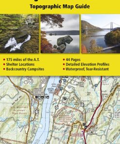
Appalachian Trail: Delaware Water Gap to Schaghticoke Mountain Map [New Jersey, New York] (National Geographic Topographic Map Guide, 1508)
Description
• Waterproof • Tear-Resistant • Topographic MapThe Delaware Water Gap to
Schaghticoke Mountain Topographic Map Guide makes a perfect traveling
companion when traversing the New Jersey and New York sections of the
Appalachian Trail (A.T.). The trail through New Jersey and New York is
surprisingly rugged, and much more remote than one would imagine given its
proximity to large population centers. For 160 miles the trail follows long
mountain ridges; travels across bogs, wetlands, and broad river valleys; and
meanders through numerous state parks, forests, and national park land.Each
A.T. Topographic Map Guide includes detailed topographic maps at a detail of 1
inch = 1 mile. Each page is centered on the A.T. and overlaps with the
adjacent pages so there is little chance of getting lost. Along the bottom of
each page is a trail profile that shows the distance between shelters, camping
areas, and trail access points. The map and trail profile provide a step by
step visual guide to hiking the trail, mile by rugged mile. The Topographic
Map Guide is built for all levels of hiking enthusiasts, from the day tripper
to the multi month ‘thru-hiker’. The front pages of the printed Topographic
Map Guide include resupply information, town inset maps, camping options, and
much more.Every Topographic Map Guide is printed on “Backcountry Tough”
waterproof, tear-resistant paper. A full UTM grid is printed on the map to aid
with GPS navigation.Other features found on this map include: Bear Mountain
State Park, Bear Mtn, Brink Road Shelter, Clarence Fahnestock Memorial State
Park, Culvers Gap, Delaware Water Gap, Delaware Water Gap National Recreation
Area, Fingerboard Shelter, Gren Anderson Shelter, Harriman State Park, High
Point Shelter, High Point State Park, Hudson Highlands State Park, Kent,
Kirkridge Shelter, Mashipacong Shelter, Morgan Stewart Shelter, Mount Algo
Shelter, Newburgh, Pawling, Pochuck Mountain Shelter, Port Jervis, RPH
Shelter, Rutherford Shelter, Stokes State Forest, Stroudsburg, Telephone
Pioneers Shelter, Ten Mile River Shelter, Unionville, Warwick, Wawayanda Mtn,
Wawayanda Shelter, Wawayanda State Park, West Mountain Shelter, West Point,
Wildcat Shelter, Wiley Shelter, William Brien Memorial Shelter, Worthington
State Forest.Map Scale = 1:63,360Folded Size = 4.25″ x 9.25″ Read more
Features:
Product Details:
- Publisher : Natl Geographic Society Maps; 2022nd edition (January 1, 2022)
- Language : English
- Map : 44 pages
- ISBN-10 : 1597756458
- ISBN-13 : 57
- Item Weight : 2.93 ounces
- Dimensions : 4 x 0.2 x 9.1 inches
- Best Sellers Rank: #397,208 in Books (See Top 100 in Books) #372 in United States Atlases & Maps (Books) #422 in Maps (Books) #1,221 in Hiking & Camping Excursion Guides (Books)
- #372 in United States Atlases & Maps (Books)
- #422 in Maps (Books)
| Dimensions | 9.29 × 6.3 × 0.51 in |
|---|---|
| Ean | 9781597756457 |
| Mpn | TI00001508 |
| Upc | 749717915084 |
| GTIN | 09781597756457 |
| Isbn | 1597756458 |
| ISBN10 | 1597756458 |
| ISBN13 | 9781597756457 |
| Brand | Natl Geographic Society Maps |
PAYMENT POLICY
SHIPPING POLICY
Most items are shipped within one business day via UPS within the Continental United States.
- Canada shipment can take up to 10 days
- Alaska, Hawaii, and Puerto Rico shipment can take up to 10 days, and some items may not be permitted to ship to these locations.
- If any shipment is not permitted to your area, full refund will be issued within two business days.
RETURNS POLICY
All returns accepted within 30 days after receiving the item.
- Refund given as money back (no exchanges)
- Return Shipping to be paid by buyer, unless item defective or damaged.
- 15% Restocking fee applies unless return due to defective or damaged product.
- Perishable or Hazardous Goods are not returnable. Returns may require compliance with Manufacturer policies.
FEEDBACK
We take our reputation seriously. We buy and sell online, so we understand the value of trust. If you are unsatisfied with your order for any reason, please Contact Us and we will work with you to resolve it to your satisfaction.
Related products
-42%

Original price was: $18.90.$10.95Current price is: $10.95.
-38%

Original price was: $20.90.$12.95Current price is: $12.95.
-30%

-35%

-20%

-20%

Original price was: $43.90.$34.95Current price is: $34.95.
-27%

Original price was: $29.90.$21.95Current price is: $21.95.
-27%

Original price was: $29.90.$21.95Current price is: $21.95.
![Appalachian Trail: Delaware Water Gap to Schaghticoke Mountain Map [New Jersey, New York] (National Geographic Topographic Map Guide, 1508)](https://swiftsly.com/wp-content/uploads/2023/12/91R8bYJItpL-100x100.jpg)