
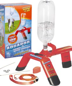
 Aquapod Bottle Launcher - Launch 2 Liter Bottles Up to 100 ft in the Air
  1")
 2")
 3")
 4")
 5")
 6")
 7")
 8")

 9")
 10")
 11")
 12")
 13")
 14")
 15")

 17")
Shenandoah National Park Map (National Geographic Trails Illustrated Map, 228)
Description
• Waterproof • Tear-Resistant • Topographic MapExpertly researched and created
in partnership with local land management agencies, National Geographic’s
Trails Illustrated map of Shenandoah National Park provides an unparalleled
tool for exploring this beautiful park. Particular attention is shown to
camping, hiking, fishing, ranger programs, and horse use in the park; and a
handy chart of waterfalls provides height, location, hiking distance, and
elevation gain for hikers. The print map includes insets of Loft Mountain,
Mathews Arm-Elkwallow, Skyland, and Big Meadows. With miles of clearly marked
trails including the Tuscarora, Appalachian, and Massanutten Mountain trails,
and the scenic roadways Skyline Drive and Virginia Scenic Byway, this map will
prove invaluable whether you’re taking in the scenery on foot or by car. Many
recreation features are noted as well, including interpretive trails, archery
ranges, ski areas, cabins, and boat launches. The map base includes contour
lines and elevations for summits.Every Trails Illustrated map is printed on
“Backcountry Tough” waterproof, tear-resistant paper. A full UTM grid is
printed on the map to aid with GPS navigation.Other features found on this map
include: Front Royal, George Washington National Forest, Massanutten Mountain,
Shenandoah.Map Scale = 1:75,000Sheet Size = 25.5″ x 37.75″Folded Size = 4.25″
x 9.25″ Read more
Features:
Product Details:
- Publisher : National Geographic Maps; 2022nd edition (January 1, 2022)
- Language : English
- Map : 2 pages
- ISBN-10 : 1566953650
- ISBN-13 : 58
- Item Weight : 3.2 ounces
- Dimensions : 4.2 x 0.3 x 9 inches
- Best Sellers Rank: #76,769 in Books (See Top 100 in Books) #7 in Camping & Hiking Topographic Maps #84 in South Atlantic United States Travel Books #85 in United States Atlases & Maps (Books)
- #7 in Camping & Hiking Topographic Maps
- #84 in South Atlantic United States Travel Books
| Dimensions | 9.09 × 4.33 × 1.42 in |
|---|---|
| Ean | 0749717012288 |
| Mpn | TI00000228 |
| Upc | 749717012288 |
| GTIN | 09781566953658 |
| Isbn | 1566953650 |
| ISBN10 | 1566953650 |
| ISBN13 | 9781566953658 |
| Brand | National Geographic Maps |
- Canada shipment can take up to 10 days
- Alaska, Hawaii, and Puerto Rico shipment can take up to 10 days, and some items may not be permitted to ship to these locations.
- If any shipment is not permitted to your area, full refund will be issued within two business days.
- Refund given as money back (no exchanges)
- Return Shipping to be paid by buyer, unless item defective or damaged.
- 15% Restocking fee applies unless return due to defective or damaged product.
- Perishable or Hazardous Goods are not returnable. Returns may require compliance with Manufacturer policies.
Related products