
![Appalachian Trail: East Mountain to Hanover Map [Vermont] (National Geographic Topographic Map Guide, 1510) Map, Folded Map](https://swiftsly.com/wp-content/uploads/2023/12/91yjMNkk5VL.jpg "Appalachian Trail: East Mountain to Hanover Map [Vermont] (National Geographic Topographic Map Guide, 1510) Map, Folded Map 1")
![Appalachian Trail: East Mountain to Hanover Map [Vermont] (National Geographic Topographic Map Guide, 1510) Map, Folded Map - Image 2](https://swiftsly.com/wp-content/uploads/2023/12/912ODHxYt1L.jpg "Appalachian Trail: East Mountain to Hanover Map [Vermont] (National Geographic Topographic Map Guide, 1510) Map, Folded Map 2")
![Appalachian Trail: East Mountain to Hanover Map [Vermont] (National Geographic Topographic Map Guide, 1510) Map, Folded Map - Image 3](https://swiftsly.com/wp-content/uploads/2023/12/B1zVjnSF8LS.jpg "Appalachian Trail: East Mountain to Hanover Map [Vermont] (National Geographic Topographic Map Guide, 1510) Map, Folded Map 3")
![Appalachian Trail: East Mountain to Hanover Map [Vermont] (National Geographic Topographic Map Guide, 1510) Map, Folded Map - Image 4](https://swiftsly.com/wp-content/uploads/2023/12/71N4U73hQRL.jpg "Appalachian Trail: East Mountain to Hanover Map [Vermont] (National Geographic Topographic Map Guide, 1510) Map, Folded Map 4")
![Appalachian Trail: East Mountain to Hanover Map [Vermont] (National Geographic Topographic Map Guide, 1510) Map, Folded Map - Image 5](https://swiftsly.com/wp-content/uploads/2023/12/712vpqqWciL-1.jpg "Appalachian Trail: East Mountain to Hanover Map [Vermont] (National Geographic Topographic Map Guide, 1510) Map, Folded Map 5")
 Map, Folded Map 6")
 Map, Folded Map 7")
 Map, Folded Map 8")
 Map, Folded Map 9")
 Paperback 10")

Appalachian Trail: East Mountain to Hanover Map [Vermont] (National Geographic Topographic Map Guide, 1510)
Description
• Waterproof • Tear-Resistant • Topographic MapThe East Mountain to Hanover
Topographic Map Guide makes a perfect traveling companion when traversing the
Vermont section of the Appalachian Trail (A.T.). The landscape of Vermont is a
variety of wooded mountains, forests of white pine and paper birch, and
rolling terrain dotted by fields and pastures. To the north and east, the A.T.
crosses short, steep hills and overgrown farmlands that characterize the
Connecticut River valley. Farther south is the rugged and rocky high country
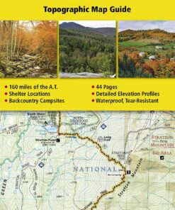
of the Green Mountains.Each A.T. Topographic Map Guide includes detailed
topographic maps at a detail of 1 inch = 1 mile. Each page is centered on the
A.T. and overlaps with the adjacent pages so there is little chance of getting
lost. Along the bottom of each page is a trail profile that shows the distance
between shelters, camping areas, and trail access points. The map and trail
profile provide a step by step visual guide to hiking the trail, mile by
rugged mile. The Topographic Map Guide is built for all levels of hiking
enthusiasts, from the day tripper to the multi month ‘thru-hiker’. The front
pages of the printed Topographic Map Guide include resupply information, town
inset maps, camping options, and much more.Every Topographic Map Guide is
printed on “Backcountry Tough” waterproof, tear-resistant paper. A full UTM
grid is printed on the map to aid with GPS navigation.Other features found on
this map include: Bennington, Big Branch Shelter, Bromley Mountain, Bromley
Shelter, Churchill Scott Shelter, Clarendon Shelter, Clarksburg State Forest,
Congdon Shelter, Cooper Lodge Shelter, Glastenbury Mountain, Goddard Shelter,
Governor Clement Shelter, Green Mountain National Forest, Greenwall Shelter,
Hanover, Happy Hill Shelter, Kid Gore Shelter, Killington Peak, Lebanon,
Little Rock Pond Shelter, Lost Pond Shelter, Manchester Center, Melville
Nauheim Shelter, Minerva Hinchey Shelter, North Adams, Norwich, Peru Peak
Shelter, Pico Camp Shelter, Rutland, Seth Warner Shelter, Spruce Peak Shelter,
Stony Brook Shelter, Story Spring Shelter, Stratton Mountain, Stratton Pond
Shelter, Thistle Hill Shelter, Velvet Rocks Shelter, Wallingford, White River
Junction, William B. Douglas Shelter, Winturri Shelter, Woodstock.Map Scale =
1:63,360Folded Size = 4.25″ x 9.25″ Read more
Features:
Product Details:
- Publisher : Natl Geographic Society Maps; 2022nd edition (January 1, 2022)
- Language : English
- Map : 44 pages
- ISBN-10 : 1597756474
- ISBN-13 : 71
- Item Weight : 2.89 ounces
- Dimensions : 4.1 x 0.3 x 9.3 inches
- Best Sellers Rank: #510,785 in Books (See Top 100 in Books) #486 in United States Atlases & Maps (Books) #510 in Maps (Books) #1,534 in Hiking & Camping Excursion Guides (Books)
- #486 in United States Atlases & Maps (Books)
- #510 in Maps (Books)
| Dimensions | 9.33 × 4.25 × 0.24 in |
|---|---|
| Ean | 9781597756471 |
| Mpn | TI00001510 |
| Upc | 749717915107 |
| GTIN | 09781597756471 |
| Isbn | 1597756474 |
| ISBN10 | 1597756474 |
| ISBN13 | 9781597756471 |
| Brand | Natl Geographic Society Maps |
| Format | Map, Folded Map |
- Canada shipment can take up to 10 days
- Alaska, Hawaii, and Puerto Rico shipment can take up to 10 days, and some items may not be permitted to ship to these locations.
- If any shipment is not permitted to your area, full refund will be issued within two business days.
- Refund given as money back (no exchanges)
- Return Shipping to be paid by buyer, unless item defective or damaged.
- 15% Restocking fee applies unless return due to defective or damaged product.
- Perishable or Hazardous Goods are not returnable. Returns may require compliance with Manufacturer policies.
Related products


![Appalachian Trail: East Mountain to Hanover Map [Vermont] (National Geographic Topographic Map Guide, 1510) Map, Folded Map](https://swiftsly.com/wp-content/uploads/2023/12/91yjMNkk5VL-100x100.jpg)